The method commonly used to extract shorelines from satellite images in the past involved painstaking image by image analysis of series of overlapping images. Also, each satellite image had to be downloaded manually from USGS or ESA and processed on a local computer. In-situ measurements of shoreline can be rather expensive and labor intensive limiting the frequency of such measurements in areas of interests, such as around coastal interventions as ports, protection works, land reclamations, etc. The lack of frequent surveys has led to limited understanding of shoreline behavior in the vicity of coastal structures and in some cases resulted in unexpected damage of assets. In addition, the development of the erosion rates over time is key information when mitigating measures are considered.
The design and implementing coastal infrastructure in data poor environments requires numerical predictions to quantify the impacts on the adjacent coast. A noncalibrated model typically comes with significant uncertainty in future shoreline positions. Here, the availability of historical shorelines allows model
calibration which can greatly reduce the uncertainty in future predictions. Another key requisite when designing coastal solutions, is a comprehensive understanding of the coastal behavior. Knowing the impact of a single storm vs. a persistent long-term erosion rate can have a great influence on the optimal solution.
Solution
The increasing availability, resolution and spatial coverage of satellite imagery in recent years now provide a powerful alternative to derive reliable, global scale shoreline data. Landsat, since 1984, and Sentinel, since 2015, are examples of publicly available satellites. Up to a few years ago, the satellite images had to be downloaded and analysed locally, making efficient analysis across the world impossible. The launching of the Google Earth Engine (GEE) platform, containing a continuously updated global satellite image archive, has enabled efficient global scale shoreline detection and has reduced image processing time to only several minutes per image.
Deltares developed a shoreline detection algorithm and applied to cloud free global annual composite images using more than 2 million historical Landsat
images. After a successful quantitative validation of this technique at multiple sites located in various geographical settings and environmental conditions,
the shoreline change rates in m/yr at transects with an alongshore spacing of 100 m along the world’s shoreline have been derived. This global data set is presented at this website.
More information on generating satellite-derived shorelines, the methods, and its accuracy, can be found in Luijendijk et al. (2018): ‘State of the World’s beaches‘.
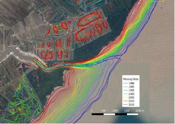
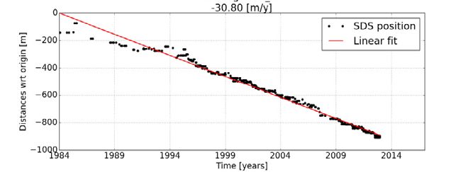
Upper panel shows annual satellite-derived shorelines between 1984 and 2016 for a river mouth in the Mekong Delta, Vietnam. Lower panel depicts the time serie represents the shoreline position along the black dotted transect, with a retreat rate of -31 m per year.